GeoStack vision: one vocabulary from file to analysis
Design · how much control you take and how it runs are independent choices
The same operator runs in a concurrent ETL, a compiled training step and a lazy cube; users choose how much control they take and how it runs, independently. Keras made that choice for training on one backend at a time; GeoStack makes it for whole pipelines, mixing run modes within one run.
1Progressive disclosure
A user starts with a packaged pipeline and steps down only as far as the work needs, as in Keras; each stop is built from the one below it.
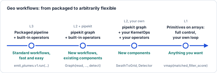
Figure 1:Four stops, from packaged to arbitrarily flexible. Each stop is built from the one to its right and hands it back.
The stops come from two independent axes: what each step computes (built-in operators down to primitives) and how steps are put together and run (packaged runners down to your own loop).
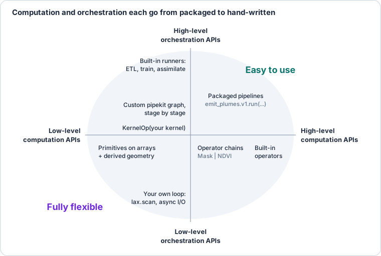
Figure 2:Computation and orchestration each go from packaged to hand-written. The four stops are points on these two axes.
Run mode (eager NumPy, compiled JAX, lazy xarray) is a third axis, orthogonal to both: any point on this picture runs in any mode the carrier allows (next section).
2Two axes
Control (how much a user writes) and run mode (how it executes) are independent: any level runs in any mode, and the operator row is what all of them share.
| Level | eager (NumPy carrier) | compiled (JAX carrier) | lazy (xarray carrier) |
|---|---|---|---|
| L3 pipeline or algorithm | emit_plumes.v1.run(...) on one scene | vardax.geo.assimilate(...) with its loop under jit | an MLD climatology over GLORYS |
| L2 operator | ndvi(scene) | jax.jit(ndvi)(jscene) | ndvi(cube), one task per chunk |
| L1 primitive | matched_filter_score on NumPy arrays | jax.vmap(matched_filter_score) | the same kernel, called per chunk by KernelOp |
Read down a column to trade convenience for control; read across a row to change how the same code runs.
3The three levels
Every package that computes (geotoolz, finitevolX, esmax, plumax, radtrax, vardax) writes its numerics as primitives on arrays, operators on carriers above them, and algorithms on readable geo types at the top. This is the one definition the other design pages link to.
| Level | Takes | Returns | Lives in |
|---|---|---|---|
| L1 primitive | arrays, or an array-only bundle (a NamedTuple or eqx.Module of arrays), plus derived numeric geometry | arrays | the lowest package that owns the numerics, in _src/array.py |
| L2 operator | a carrier (GeoArray, DataArray) | the same carrier family | any package that may import that carrier |
| L3 algorithm or packaged pipeline | readable geo types (GeoMap, GeoTracks, GeoImageSeries) | readable geo types | the package that runs it (esmax, vardax, plumax) |
Derived numeric geometry, never the georeference. Space, time and viewing geometry as arrays: Δx, Δy, cell areas, Δt, sun and view angles, unit vectors on the sphere. A primitive never receives a CRS, a transform object or a pyproj handle.
Operators derive it.
KernelOpgenerates the operator when the only geometry is a dim name (NDVI, the matched filter); an operator is hand-written when it must derive geometry from the carrier.Algorithms cross the carrier boundary once. They unwrap at entry, call L1 primitives directly inside their loops, and rewrap at exit; they never call L2 operators per step.
A packaged pipeline is a graph of named L2 operators with readable types at its ends, so the four stops below are the three levels plus the graph that composes them.
Exceptions. Geometry operators whose engine is not array code (GDAL rasterize, shapely predicates) have no primitive and are eager only. Reprojection splits: the operator computes source pixel coordinates with pyproj; the primitive is the gather.
Primitives check shapes, not meaning. Units, CRS and grid compatibility are checked at L2 and L3.
Enforced by a test in geostack’s dependency-graph suite:
*/_src/array.pyimports none of geoarray, xarray, pyproj, rasterio, geopandas or shapely.
Where each level sits in every package above GeoStack is on Levels across the stack; where the operator packages sit relative to each other is the tiers.
4Control: four stops, one plume pipeline
A user picks how much control to take, as in Keras’s progressive disclosure (Sequential → functional → subclassing). The four stops are the ones in Figure 1.
| Stop | You call | You hold | Typing | Who |
|---|---|---|---|---|
| 1. Packaged pipeline (L3) | plumax.pipelines.emit_plumes.v1.run(...) | readable geo types | checked on entry and exit | operations, production, benchmarks |
| 2. Graph of operators (L2 + pipekit) | pipekit.Graph(read=..., matched_filter=..., ...) | named stages | dims, per stage | analysts building a new workflow |
| 3. Operators (L2) | SwathToGrid(...)(swath), your own KernelOp | a carrier with named dims | dims and grids | method developers adding a component |
| 4. Primitives (L1) | matched_filter_score(x, mu, sigma, t) | .data and derived geometry | shapes | full control: new numerics, your own loop |
One running example: methane plumes from one EMIT scene. Each stage needs a different kind of code from a different repo, so every level shows up.
| Stage | Computes | L1 primitive (repo) | L2 operator (repo) |
|---|---|---|---|
| read | L1B radiance on the sensor swath, 285 bands | — | geoproducts.emit.ReadL1B (geotoolz) |
| matched filter | α per pixel, μ and Σ per detector column | matched_filter_score (radtrax) | MatchedFilter, a KernelOp (radtrax[geo]) |
| orthorectify | swath → UTM grid at 60 m | gather_bilinear (geoops) | SwathToGrid: pyproj → source coordinates (geoops) |
| detect | plume probability per pixel | PlumeUNet.__call__ (geonnax) | Detector, a JaxOperator (plumax[geo]) |
| vectorize | mask → polygons | none: GDAL | geoops.geom.Vectorize, eager only |
| the pipeline | all of the above | — | plumax.pipelines.emit_plumes (plumax) |
The pipeline lives in plumax because it is the lowest package that may import all four: radtrax (GeoModels, tier below), geonnax (GeoML) and geotoolz (GeoStack). The matched filter runs before orthorectification on purpose: its statistics are per detector column, which only exist in sensor geometry.
Stop 1 — L3: a packaged pipeline
The user names a scene and gets plumes back; nothing about bands, swaths or models is visible.
# a versioned, packaged pipeline
pipeline: Pipeline = plumax.pipelines.emit_plumes.v1
run: PipelineRun = pipeline.run(scene_id="EMIT_L1B_RAD_001_20260714T081512")

# GeoPoints["variable obs"]: one row per plume (polygon, area, max ΔXCH₄)
plumes: Detections = run.output
Stop 2 — L2 + pipekit: the same pipeline as a graph
This is the body of emit_plumes.
Every stage is a named, built-in operator; an analyst copies it, reorders or adds stages, and runs it.
def emit_plumes(scene_id: str) -> pipekit.Graph:
    # → GeoSwath["band row col"], 285 bands; lat/lon and sun/view angles as leaves
    read: Operator = geoproducts.emit.ReadL1B(scene_id)

    # t: the unit CH₄ absorption spectrum at EMIT's wavelengths, (C,)
    target: Float[Array, "C"] = radtrax.ch4_unit_spectrum(EMIT_WAVELENGTHS)
    # GeoSwath["band row col"] → GeoSwath["row col"]: α, fitted per detector column
    matched_filter: Operator = radtrax.geo.MatchedFilter(
        target=target, dim="band", fit_per="col"
    )

    # GeoSwath["row col"] → GeoArray["y x"]: the scene's UTM zone at 60 m
    ortho: Operator = geoops.geom.SwathToGrid(crs="utm", resolution=60.0)

    # GeoArray["y x"] → GeoArray["y x"]: plume probability, compiled
    detect: Operator = plumax.geo.Detector.load("plume_unet_v7")

    # p > 0.5 → GeoArray["y x"], bool
    threshold: Operator = geoops.Threshold(0.5)

    # mask → polygons; eager only (GDAL)
    vectorize: Operator = geoops.geom.Vectorize()

    return pipekit.Graph(
        read=read,
        matched_filter=matched_filter,
        ortho=ortho,
        detect=detect,
        threshold=threshold,
        vectorize=vectorize,
    )


graph: pipekit.Graph = emit_plumes("EMIT_L1B_RAD_001_20260714T081512")
plumes: Detections = graph.run()
Stop 3 — L2: operators, one per concern
Inside each stage: an operator takes a carrier, derives the geometry its primitive needs, calls the primitive, and rewraps. Three shapes of operator appear here.
# geoops/geom/operators.py — a geometry operator: pyproj here, numerics in L1
class SwathToGrid(Operator):
    backends: tuple[str, ...] = ("numpy", "jax")

    def __init__(self, crs: str, resolution: float) -> None:
        self.crs: str = crs
        self.resolution: float = resolution

    def __call__(self, swath: GeoSwath["row col"]) -> GeoArray["y x"]:
        # the target grid: UTM zone from the swath centre, extent from its footprint
        target: GridSpec = geoarray.target_grid(
            swath, crs=self.crs, resolution=self.resolution
        )
        # derived geometry: fractional source (row, col) of every target pixel (pyproj + KD-tree)
        rows: Float[Array, "H W"]
        cols: Float[Array, "H W"]
        rows, cols = geoarray.swath_source_coords(swath, target)
        # L1: q(y, x) = ∑ᵢ wᵢ s(rᵢ, cᵢ), bilinear
        gridded: Float[Array, "H W"] = gather_bilinear(swath.data, rows, cols)
        return GeoArray.from_grid(gridded, target, dims=("y", "x"))


# radtrax/geo/operators.py — behind radtrax[geo]; a fitted operator built from KernelOps
class MatchedFilter(FittableOperator):
    def fit(self, swath: GeoSwath["band row col"]) -> "MatchedFilter":
        # μ(col) and Σ(col) over the rows of each column: "(r,c)->(c),(c,d)", Σ on
        # (band, band2); the kernel takes one column, so it is vectorized over col
        stats: KernelOp = KernelOp(
            background_stats,
            KernelSpec("(r,c)->(c),(c,d)", vectorize=True),
            core={"r": "row", "c": "band", "d": "band2"},
        )
        # row is consumed, so the outputs are no longer swaths: plain named arrays
        mu: DimArray["col band"]
        sigma: DimArray["col band band2"]
        mu, sigma = stats(swath)
        return self.with_fitted(mu=mu, sigma=sigma)

    def __call__(self, swath: GeoSwath["band row col"]) -> GeoSwath["row col"]:
        # one column at a time: consumes rows and bands, vectorized over col; Σ's
        # second axis is band2, and the kernel's "C C" hint checks |band| = |band2|;
        # t is the same for every column, so it is a parameter, not mapped
        score: KernelOp = KernelOp(
            matched_filter_score,
            KernelSpec("(r,c),(c),(c,d)->(r)", vectorize=True),
            core={"r": "row", "c": "band", "d": "band2"},
            t=self.target,
        )
        return score(swath, self.mu, self.sigma)


# plumax/geo/detector.py — behind plumax[geo]; geonnax's network, carrier handling here
class Detector(JaxOperator):
    net: PlumeUNet  # an eqx.Module from geonnax; weights are leaves
    patch: int = eqx.field(static=True, default=256)

    def __call__(self, alpha: GeoArray["y x"]) -> GeoArray["y x"]:
        # 256 × 256 patches with 32-pixel overlap: (P, 256, 256), transforms (P, 6)
        patches: GeoArray["patch y x"] = geopatcher.split(
            alpha, size=self.patch, overlap=32
        )
        # one input channel per patch
        x: Float[Array, "P 1 H W"] = einx.rearrange("p h w -> p 1 h w", patches.data)
        # L1 under vmap: logits = f_θ(x) per patch
        net_batched: Callable = jax.vmap(self.net)
        logits: Float[Array, "P H W"] = net_batched(x)
        # p = σ(logits)
        prob: Float[Array, "P H W"] = jax.nn.sigmoid(logits)
        # stitch back onto alpha's grid, averaging the overlaps
        prob_patches: GeoArray["patch y x"] = patches.rewrap(prob, dims=patches.dims)
        return geopatcher.stitch(prob_patches, like=alpha)
The three shapes: a geometry operator that derives index arrays with pyproj (SwathToGrid), a fitted operator made of KernelOps (MatchedFilter), and a JAX operator around a network (Detector).
Each lives in the package that may import both its carrier and its primitive.
Stop 4 — L1: primitives, arrays only
No carrier, no CRS: arrays in, arrays out, each in its owner’s _src/array.py.
# radtrax/_src/array.py — one detector column: R rows, C bands
def matched_filter_score(
    x: Float[Array, "R C"],
    mu: Float[Array, "C"],
    sigma: Float[Array, "C C"],
    t: Float[Array, "C"],
) -> Float[Array, "R"]:
    # x̃ᵣ = xᵣ − μ
    xc: Float[Array, "R C"] = einx.subtract("r c, c", x, mu)
    # w = Σ⁻¹t, solved, never inverted
    cov: lx.MatrixLinearOperator = lx.MatrixLinearOperator(
        sigma, lx.positive_semidefinite_tag
    )
    w: Float[Array, "C"] = lx.linear_solve(cov, t).value
    # αᵣ = x̃ᵣᵀw / tᵀw
    num: Float[Array, "R"] = einx.dot("r c, c -> r", xc, w)
    norm: Float[Array, ""] = einx.dot("c, c ->", t, w)
    return num / norm


# geoops/geom/_src/array.py — bilinear gather at fractional source coordinates
def gather_bilinear(
    s: Float[Array, "R C"], rows: Float[Array, "H W"], cols: Float[Array, "H W"]
) -> Float[Array, "H W"]:
    xp: ModuleType = array_namespace(s)  # numpy or jax.numpy
    n_rows: int = s.shape[0]
    n_cols: int = s.shape[1]
    # inside the source: 0 ≤ r ≤ R − 1 and 0 ≤ c ≤ C − 1; outside gives NaN, never an index error
    inside_r: Bool[Array, "H W"] = (rows >= 0) & (rows <= n_rows - 1)
    inside_c: Bool[Array, "H W"] = (cols >= 0) & (cols <= n_cols - 1)
    inside: Bool[Array, "H W"] = inside_r & inside_c
    # r₀ = ⌊r⌋ clipped to [0, R − 2], c₀ likewise, so r₀ + 1 and c₀ + 1 are in range;
    # a point on the last row gets r₀ = R − 2, δr = 1, and exactly the last row's value
    r_floor: Float[Array, "H W"] = xp.floor(rows)
    c_floor: Float[Array, "H W"] = xp.floor(cols)
    r0: Int[Array, "H W"] = xp.clip(r_floor, 0, n_rows - 2).astype(int)
    c0: Int[Array, "H W"] = xp.clip(c_floor, 0, n_cols - 2).astype(int)
    # δr = r − r₀, δc = c − c₀
    dr: Float[Array, "H W"] = rows - r0
    dc: Float[Array, "H W"] = cols - c0
    # the four neighbours s₀₀, s₀₁, s₁₀, s₁₁
    s00: Float[Array, "H W"] = s[r0, c0]
    s01: Float[Array, "H W"] = s[r0, c0 + 1]
    s10: Float[Array, "H W"] = s[r0 + 1, c0]
    s11: Float[Array, "H W"] = s[r0 + 1, c0 + 1]
    # q = (1−δr)(1−δc) s₀₀ + (1−δr)δc s₀₁ + δr(1−δc) s₁₀ + δrδc s₁₁
    top: Float[Array, "H W"] = (1 - dc) * s00 + dc * s01
    bottom: Float[Array, "H W"] = (1 - dc) * s10 + dc * s11
    q: Float[Array, "H W"] = (1 - dr) * top + dr * bottom
    return xp.where(inside, q, xp.nan)


# geonnax — the network is itself an L1 function of arrays
class PlumeUNet(eqx.Module):
    def __call__(self, x: Float[Array, "1 H W"]) -> Float[Array, "H W"]: ...
The stop-4 user writes a new retrieval as a function like matched_filter_score, tests it on arrays, and runs it in their own loop:
# radiance in sensor geometry, raw: (R, Cols, C); per-column statistics: (Cols, C), (Cols, C, C)
radiance: Float[Array, "R K C"] = swath.data_bands_last()
# map the kernel over the K detector columns: α, (R, K)
per_column: Callable = jax.vmap(
    matched_filter_score, in_axes=(1, 0, 0, None), out_axes=1
)
alpha: Float[Array, "R K"] = per_column(radiance, mu_cols, sigma_cols, t)
Each stop is built from the one below and gives it back: the pipeline’s matched_filter stage is the MatchedFilter operator, whose call is a KernelOp around matched_filter_score.
5Run modes: the carrier chooses
The backend is chosen by the carrier passed in, never by a global setting, because one pipeline mixes run modes: I/O is eager NumPy, assembly is lazy xarray, training is compiled JAX.
| Run mode | Carrier | Good for | Not for |
|---|---|---|---|
| eager | NumPy GeoArray | reading, per-scene processing, concurrent ETL | gradients, cubes larger than memory |
| compiled | JAX GeoArray | training, assimilation, anything under grad or vmap | I/O, variable shapes |
| lazy | xarray DataArray / Dataset | many files, selection by value, out-of-core reductions | per-patch work, jit |
The same operator in each mode:
ndvi: geoops.NDVI = geoops.NDVI()

# eager, NumPy: scene is GeoArray["band y x"]
m: GeoArray["y x"] = ndvi(scene)

# compiled: the same op, jitted, on a JAX carrier
ndvi_jit: Callable = jax.jit(ndvi)
jscene: GeoArray["band y x"] = scene.to_jax()
m_jax: GeoArray["y x"] = ndvi_jit(jscene)

# lazy: cube is DataArray["time band y x"], one task per chunk
m_cube: DataArray["time y x"] = ndvi(cube)
Crossing between modes is always explicit, a named call at a known place: to_jax() / to_numpy() between eager and compiled, GeoArray.from_xarray() / to_xarray() between eager and lazy.
An operator given two carriers of different modes refuses and names the crossing; nothing converts silently.
1  index the training scenes          lazy · xarray
│    many files, selected by date and region
│  GeoArray.from_xarray()             crossing 1
▼
2  read and cut patches               eager · NumPy
│    concurrent I/O in the runner
│  to_jax()                           crossing 2
▼
3  train the detector                 compiled · JAX
│    jit, grad and vmap; the only stage that compiles
│  to_numpy()                         crossing 3
▼
4  score the validation scenes        eager · NumPy
│  to_xarray()                        crossing 4
▼
5  write maps and metrics             lazy · xarray, to Zarr
Only the training stage compiles; the I/O before it and the writing after it never run under JAX.
Keras chooses one backend for a whole program (KERAS_BACKEND); GeoStack chooses per stage, which is the main way the analogy breaks.
6Typing: one object, checked in different places
Strict for pipelines and loose for exploration is a question of where the check runs, not of different classes.
Readable types are aliases of GeoArray, GeoSwath and GeoPoints with named dims, so an exploration result enters a pipeline with no conversion.
| Level | What is checked | When | Failure |
|---|---|---|---|
| Primitive | array shapes (jaxtyping) | at call, and at trace time under jit | shape error |
| Operator | dim names and grid compatibility (check_dims, check_compatible) | at call | DimError, GridMismatchError |
| Pipeline | the readable type: dims, coordinates, CRS, time stamps | on entry and on exit | the pipeline refuses before any work |
# exploration: a carrier from a notebook
scene: GeoArray["band y x"] = geoarray.read("S2_20260714.tif", dims=("band", "y", "x"))

# the same object is a GeoImage: a type name checked on dims, not a subclass
assert geoarray.types.matches(scene, GeoImage)  # GeoImage ≡ GeoArray["band y x"]

# a pipeline checks on entry
stack: GeoArray["time y x"] = geoarray.stack(frames, dim="time")
pipelines.detect_plumes(stack)
# DimError: detect_plumes expects GeoImage (band, y, x); got (time, y, x). Select one time first.7Stepping down a level in one line
Keras’s weak spot was the drop from fit() to a custom loop: past a point, the high level gave nothing back and users rewrote.
Here every level exposes the one below it.
# a pipeline is a pipekit graph of operators: pull one stage out
pipe: pipekit.Graph = plumax.pipelines.emit_plumes.build(
    scene_id="EMIT_L1B_RAD_001_20260714T081512"
)
stage: radtrax.geo.MatchedFilter = pipe["matched_filter"]

# swap it for your own operator, keep the rest of the pipeline
mine: Operator = MyRetrieval(dim="band", fit_per="col")
pipe_mine: pipekit.Graph = pipe.replace("matched_filter", mine)

# an operator exposes its primitive and spec
kernel: Callable[..., Float[Array, "R"]] = stage.kernel  # matched_filter_score
spec: KernelSpec = stage.spec  # "(r,c),(c),(c,d)->(r)", vectorized over col

# and runs it yourself on one column's raw arrays
alpha_col: Float[Array, "R"] = kernel(
    radiance[:, 0], stage.mu.data[0], stage.sigma.data[0], stage.target
)
The rule this needs: no pipeline stage is a closure or a private function; each is a named operator, and each operator that wraps a kernel names it.
8Principles
Write numerics once, as primitives. Arrays and derived numeric geometry in, arrays out; no carrier, no CRS.
Operators wrap primitives for carriers. Generated by
KernelOpwhen the only geometry is a dim name; hand-written when geometry must be derived.Pipelines are graphs of named operators. No hidden stage; any stage can be pulled out or replaced.
The carrier chooses the run mode. No global backend; crossings are explicit calls.
One object at every level. Readable types are aliases; strictness is where the check runs.
Never align silently. Two inputs on different grids refuse; xarray’s inner join is never the default.
Dependencies point down. Primitives live in the lowest package that owns the numerics; carrier code lives where the carrier can be imported.
9What this is not
Not async operators. Concurrency is a property of the runner (pipekit) and of I/O (geocatalog, geocloud). Operators stay synchronous, pure functions the runner can schedule.
Not a global backend switch. A pipeline that needs JAX for one stage does not run its I/O under JAX.
Not a new xarray. Selection by value, groupby and many-file assembly stay xarray’s; GeoStack adds operators that also run on xarray.
Not accessors. No
.geoonDataArray; operators are functions orOperators you import.Not
GeoSeries. That is geopandas’ column of shapes; the series types areGeoImageSeriesandGeoTimeSeries.
10How the design pages fit
Read top to bottom: the vision, then the one data structure, then how an operation is written once, then where packages and levels sit.
| Design page | Which part of the vision it settles |
|---|---|
| Case studies | thirteen real workflows run through this page; the findings CS-F1 to CS-F17 |
| geoarray | the one object: carriers, named dims, readable types, the crossing to JAX |
| Labeled lane | the crossing to xarray, and when to take it |
| pipekit kernels | the machinery that lets the carrier choose the run mode: adapters, one Signature, KernelOp |
| Operators | the middle level: geoops and xrops, their tiers, geometry operators, lifting over cubes |
| Package layout | where each package sits in geotoolz and xrtoolz |
| Levels across the stack | the three levels in GeoNumerics, GeoML and GeoModels |
| esmax | the GeoModels workspace of simple models for short-window data assimilation |
| Decisions | every decision and open question, with one ID each |
| not yet written | packaged pipelines (L3): how they are built, checked, versioned and run concurrently |
11Open questions
| ID | Question | Recommended | Alternative |
|---|---|---|---|
| VI-V1 | Where packaged pipelines live | each in the package that owns its domain (plumax.pipelines, esmax_ocean.pipelines), built on pipekit | one geopipelines package for all of them |
| VI-V2 | Which run modes are first-class at first | eager and compiled; lazy only through apply_ufunc | all three equally from the start, tripling the test matrix |
| VI-V3 | Which pipelines to package first | the ones already run: methane plume detection, SLA mapping | a generic set chosen in advance |
| VI-V4 | How a pipeline runs concurrently | the pipekit runner schedules synchronous operators; I/O stages are concurrent | async operators |
| VI-V5 | Whether pipeline checks can be switched off for speed | no for entry checks (cheap, once per run); per-stage dim checks may be turned off | all checks configurable |