xrcf: conventions for the xarray side of GeoStack
xrcf is the floor of the xarray side of GeoStack, as geoarray is of the GeoArray side: the CF variable registry, the conventions for names, attributes, coordinates and time, the CRS as a CF grid mapping, validation, the typed vocabulary of a request (BBox, TimeRange, levels), and subsetting by it. It computes nothing. It is a proposed package of the xrtoolz workspace (distribution xrtoolz-cf), at its tier 0, below both the readers and the operators. Status: proposed, at design-sketch depth.
At a glance
| Layer, tier | GeoStack, xrtoolz workspace, tier 0 |
| Imports | xarray, pandas, NumPy, pyproj; nothing from GeoNumerics or Core |
| Imported by | xrops, xrproducts |
| Takes over | xrproducts.types (the Variable registry, the request vocabulary, subsetting, validation); xrops.cf; the CRS half of xrops.geom |
| Does not own | computing anything (xrops); reading archives (xrproducts); the carrier itself (xarray); reprojection (xrops, through rioxarray) |
| Status | proposed; no package yet |
| Tracked in | the layer map, “The gap: a floor for the xarray side” |
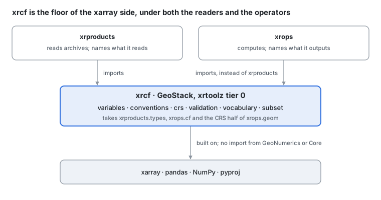
Where xrcf sits · the floor of xrtoolz.
With xrcf at the bottom, xrops and xrproducts become siblings over it, as geoops and geoproducts are over geoarray, and xrops no longer imports a reader to name a variable. This page is the design; core types, the registry and the code survey are in xrcf: design details.
The problem
The methane example reads ERA5 winds from the Climate Data Store and a TROPOMI L2 file, and the two disagree on everything but the physics: ERA5 calls the eastward wind u, its global longitudes run 0 to 360 and its latitudes descend; TROPOMI has its own names and no CRS. Before xrops can compute anything, both are renamed, normalised, given a CRS, validated and cut to the plume’s box:
| Step | The convention it needs | Where it is coded today |
|---|---|---|
| Ask for the region, time and levels | a typed request | xrproducts.types: Request, BBox, TimeRange, DepthRange, PressureLevels |
| Rename to CF standard names | a registry of variables with per-source aliases | xrproducts.types: Variable, REGISTRY (61 variables), resolve, register, apply_cf_attrs; xrops.cf: rename_to_cf_standard_names, rename_variables |
| Normalise coordinates and time | longitude range, latitude order, CF time | xrops.cf: validate_longitude, validate_latitude, check_dataset_coords, decode_cf_time, validate_time |
| Attach a CRS | a grid mapping | xrops.geom: assign_crs, get_crs, utm_crs_for, local_frame, through rioxarray |
| Check the result | a validation report | xrproducts.types: validate_variable, validate_dataset, ValidationReport |
| Cut to the plume’s box | subsetting by bbox, time and condition | xrproducts.types: subset_bbox, subset_time, subset_where; xrops.geom.subset_to_region |
| Name what an operator outputs | the same registry | xrops imports Variable, apply_cf_attrs or REGISTRY from xrproducts.types eight times: atm (wrf, wind, vertical), atm/gas/ch4, viz/cmaps, cf, geom/subset |
That last row is the problem. On the GeoArray side the carrier’s vocabulary lives at the bottom, in geoarray, and geotoolz has a rule that geoops never depends on geoproducts. On the xarray side the same vocabulary is split between a reader and the operators, so xrops imports a reader package to name a variable, which is exactly the edge geotoolz forbids.
A convention, written down
xrcf holds four kinds of object, each a frozen record or a pure function on a Dataset.
A variable. A Variable names a physical quantity once: its name in the stack, its CF standard name, units, long name, valid range, dtype and colour map, and its request identifier at each provider ({"cmems": "thetao", "cds": "sea_surface_temperature"}). The registry holds the curated ones, 61 today; users register their own. Every reader and every operator names a quantity through it, so the eastward wind (canonical name u, standard name eastward_wind) is one entry whether ERA5 delivered it or an operator computed it.
A convention. A Dataset is in convention when its variables carry standard names and units, longitudes lie in [−180, 180), latitudes ascend, time is decoded to datetime64, and its spatial dims are lon/lat, or x/y with a CRS. Each rule is a check and a fix, so a reader can normalise what it opens and an operator can refuse what it cannot use.
Today’s code checks more than it fixes: after wrapping longitudes it does not sort them, it does not reorder descending latitudes, and subset_bbox returns nothing for a box that crosses the antimeridian. xrcf adds those three fixes.
A CRS. Stored the CF way: a grid-mapping variable holding crs_wkt, referenced from each data variable’s grid_mapping attribute, EPSG:4326 for lon/lat data. pyproj parses it; rioxarray reads the same attributes when xrops reprojects.
A request. Variables, a BBox, a TimeRange, and pressure levels or a depth range: the same object a reader fetches with and a subset cuts with, so what was asked for and what was kept cannot drift apart.
Validation returns a report of issues with a severity each, not an exception, so a pipeline decides what to stop on.
Modules and boundaries
Six modules, all on xarray, pandas, NumPy and pyproj; none needs dask, rioxarray or JAX.
| Module | Owns | Comes from |
|---|---|---|
xrcf.variables | Variable, the registry, register, resolve, per-source aliases, apply_cf_attrs | xrproducts.types (variable.py) |
xrcf.conventions | renaming to and from CF standard names; longitude range and latitude order; CF time decoding; coordinate checks | xrops.cf: rename_to_cf_standard_names, rename_from_cf_standard_names, rename_coords, rename_variables, validate_longitude, validate_latitude, decode_cf_time, check_dataset_coords |
xrcf.crs | attaching and reading a CRS as a CF grid mapping; the UTM zone for a point; local tangent frames; lon/lat to x/y and back; the resolution of a dataset | xrops.geom: assign_crs, get_crs, utm_crs_for, LocalFrame, local_frame, assign_local_xy, lonlat_to_xy, xy_to_lonlat, calc_latlon, get_dataset_resolution |
xrcf.validation | Severity, Issue, ValidationReport, validate_variable, validate_dataset, validate_time | xrproducts.types (validation.py); xrops.cf.validate_time |
xrcf.vocabulary | BBox, TimeRange, DepthRange, PressureLevels, Request, Station, StationCollection | xrproducts.types |
xrcf.subset | subsetting by a bbox, a time range or a condition; selecting variables | xrproducts.types: subset_bbox, subset_time, subset_where; xrops.geom.select_variables |
What xrcf owns, and what it hands off
The test for every name: does it say what a Dataset means, or check or fix that it says it in the stack’s convention, without computing a new field? Then xrcf owns it.
| Neighbour | xrcf owns | The neighbour owns | The line |
|---|---|---|---|
| xrops | names, conventions, the CRS, requests | everything that computes: reprojection, rasterising, regions, mosaics, footprints, every diagnostic | computing anything is xrops’ |
| xrproducts | the vocabulary a reader uses | reading archives (CMEMS, CDS, AEMET), local L2 openers, inventories | a reader names what it reads through xrcf |
| xarray, rioxarray | the stack’s conventions | the carrier; raster reprojection | xrcf writes CF attributes that rioxarray reads |
| geoarray | the xarray side’s vocabulary | the GeoArray side’s carrier and its coordinates | the two floors mirror each other; whether they share a request vocabulary is decision 6 |
| geocatalog | — | GeoSlice queries over a file index | the same open question |
What moves in
| From | What | Its users then import |
|---|---|---|
xrproducts.types | the whole subpackage: the registry, the vocabulary, subsetting, validation | xrcf; xrproducts’ readers and xrops both |
xrops.cf | renaming, coordinate and time conventions, validation helpers | xrcf |
xrops.geom | crs.py apart from reproject and reproject_match; select_variables from subset.py | xrcf; reprojection, rasterising, regions, mosaics, footprints and subset_to_region (which needs regionmask) stay in xrops |
In use
ERA5 winds for the plume, from request to a Dataset xrops can compute on. Every xrcf name is proposed; the reader call is xrproducts’.
# Shapes: T times; K pressure levels; Ny × Nx cells (the Dataset's dims)

import xrcf

# proposed (xrcf)
request = xrcf.vocabulary.Request(
    variables=("u", "v"),
    bbox=xrcf.vocabulary.BBox(lon_min=-3.5, lon_max=-2.5, lat_min=39.0, lat_max=40.0),
    time=xrcf.vocabulary.TimeRange(start, end),
    levels=xrcf.vocabulary.PressureLevels((850, 900, 950)),
)
# not pinned (xrproducts)
era5 = cds_source.fetch(request)  # → (T, K, Ny, Nx)

# proposed (xrcf)
# u → eastward_wind, v → northward_wind, through the registry's aliases
era5 = xrcf.conventions.to_standard_names(era5, source="cds")
# proposed (xrcf)
# longitudes into [−180, 180), latitudes ascending, time decoded
era5 = xrcf.conventions.normalise(era5)
# proposed (xrcf)
# a CF grid mapping holding EPSG:4326's WKT
era5 = xrcf.crs.assign(era5, "EPSG:4326")
# proposed (xrcf)
report = xrcf.validation.validate_dataset(era5)
# proposed (xrcf)
era5 = xrcf.subset.by_request(era5, request)  # → (T, K, Ny', Nx')
From here xrops computes: the wind at plume height, a reprojection to the instrument’s grid, a diagnostic. Each output names its variable through the same registry.
Integration across the stack
| Consumer | Uses today | With xrcf |
|---|---|---|
| xrops | eight imports of xrproducts.types; its own cf and geom CRS helpers | xrcf for names, conventions, the CRS and requests; no import of xrproducts |
| xrproducts | types as a subpackage of its own | xrcf; its readers keep their aliases in the registry (decision 5) |
| geocatalog | GeoSlice | unchanged unless decision 6 lands |
The change is an import, and it removes xrops’ only reason to import a reader:
# Today:
# today (xrproducts)
from xrproducts.types import Variable, apply_cf_attrs

# After:
# proposed (xrcf)
from xrcf.variables import Variable, apply_cf_attrs
xrproducts.types keeps deprecated aliases for one release.
Decisions and open questions
One decided, three leaning, four open. Each entry gives the position first, then the trade-off.
1. A floor for the xarray side
Leaning: yes, one small package. Proposed on the layer map: xrops and xrproducts both import it and neither imports the other, mirroring geoops and geoproducts over geoarray. The alternative, moving types into xrops, would make every reader import the operators.
2. Name and home: xrcf, in the xrtoolz workspace
Leaning. Distribution xrtoolz-cf, import xrcf, as a workspace member next to xrtoolz-ops and xrtoolz-products, so it versions and releases with them.
3. It computes nothing
Decided (5 Nov 2026, on the layer map). Computing anything stays in xrops, reading in xrproducts. That keeps xrcf’s dependencies to xarray, pandas, NumPy and pyproj.
4. How the CRS is stored
Open. xrops attaches a CRS through rioxarray, whose spatial_ref coordinate already is a CF grid-mapping variable holding crs_wkt. So the convention is settled; the choice is the dependency and the name. Leaning: write the same CF attributes with pyproj alone, under rioxarray’s name spatial_ref, so rioxarray reads them unchanged and xrcf does not import it.
5. Where a source’s aliases live
Open. Today each Variable carries the identifiers of every source (cmems, cds, …), so the registry knows every reader. The alternative is for each reader to register its aliases when it is imported. Leaning: keep them in the registry, where one look shows how a variable is spelled everywhere; revisit when a third-party reader appears.
6. One request vocabulary with geocatalog?
Open, on the layer map. geocatalog’s GeoSlice and xrcf’s Request both say “this region, this time”. Sharing one would need a home below both workspaces, which neither has. Leaning: keep them apart, with converters both ways, until a second user needs both.
7. Build on cf_xarray?
Open. cf_xarray already reads standard names, axes and grid mappings. Nothing in the stack uses it today. Leaning: use it inside xrcf where it saves code, but keep xrcf’s API, so the registry and the stack’s stricter conventions stay ours.
8. Validation reports, not exceptions
Leaning. Keep xrproducts.types’ design: validation returns a ValidationReport of issues with severities, and a caller decides what to stop on.
Roadmap
Four waves, each a GitHub issue epic in the xrtoolz repository.
| Wave | Delivers | Ends | Needs |
|---|---|---|---|
| 0. The package | xrtoolz-cf as a workspace member; CI; the capability index | — | — |
| 1. Registry and vocabulary | xrproducts.types moved whole into xrcf.variables, xrcf.vocabulary, xrcf.validation, xrcf.subset, with aliases left behind for one release | xrops’ eight imports of xrproducts | 0 |
| 2. Conventions and CRS | xrops.cf and the CRS half of xrops.geom into xrcf.conventions and xrcf.crs (decision 4) | the convention code in xrops | 1 |
| 3. Consumers switch | xrops and xrproducts import xrcf; the aliases go | the old paths | 1, 2 |
Wave 1 is mostly a move: xrproducts.types already depends on nothing but xarray, pandas and NumPy.
Sources
The GeoStack layer map, “The gap: a floor for the xarray side”: xrcf’s place, imports and moves.
The CF Conventions: standard names, units, coordinates and grid mappings.
Code read on 5 Nov 2026 at xrtoolz
b3855d7:xrproducts/types/_src/(variable.py,geometry.py,levels.py,request.py,station.py,subset.py,time.py,validation.py); xropscf/_src/validation.py,geom/_src/crs.py,geom/_src/subset.py, and the eight call sites that importxrproducts.types.