The geo data stack
Report 16 · Realignment plan for pipekit, xrtoolz and geotoolz across 18 distributions
Abstract
Three repositories ship 18 distributions: pipekit (7), xrtoolz (6) and geotoolz (5), and none of them merges into another. pipekit is the composition layer, geotoolz-cloud, geotoolz-catalog and geotoolz-patcher serve both carrier lanes, geotoolz and geotoolz-products are the GeoTensor lane, and the xrtoolz family is the xarray lane. We run one synthetic methane scene through the packages that touch it (pipekit and pipekit-array, geocatalog, geopatcher, geotoolz and the xrtoolz core, reader and top-level package), and the matched filter’s noise lands within 3.2 % of its closed form. However, six seams still need work: 1) two Signature classes that cannot share a pipeline, 2) eight model wrappers for three backends, 3) shared xarray vocabulary that lives in a downloader, 4) a training dataset that imports a geopatcher module which was removed on 8 October, 5) no rule for where a mission reader lives, and 6) a distribution name on PyPI that belongs to another project. The running example exercises four of them on the pinned code (the signatures, the vocabulary’s dependency, the training dataset and the dependency names). We read the model wrappers and the mission readers from the source in the audit, and the run does not import pipekit-jax, geotoolz-products, xrtoolz-einx, xrtoolz-grad or xrtoolz-sklearn. In this page we decide each seam, and we pull together the open questions which Reports 3, 6, 7 and 11 left on them.
About this report
| Status | Proposal. It replaces the 7 October draft of this plan, which predates geotoolz-cloud and geotoolz-products; this page is the source of truth |
| Reading time | about 30 minutes |
| Audience | anyone changing where a symbol lives in pipekit, xrtoolz or geotoolz, or publishing them |
| Companions | Report 2 (pipekit core); Report 3 (geotoolz and xrtoolz on pipekit, whose open questions 4 and 7 this page answers); Report 6 and Report 7 (whose PyPI-name questions this page answers); Report 11 (whose A5 is this page’s D1) |
| Code checked against | the revisions pinned in references/: pipekit and its six sister packages at 0.0.2 (ef3c17f); geotoolz 0.10.2 with geotoolz-catalog 0.5.1, geotoolz-patcher 0.10.2, geotoolz-cloud 0.4.1 and geotoolz-products 0.4.2 (088475e); xrtoolz 0.0.5 with xrtoolz-core 0.0.2 and xrtoolz-reader 0.0.4 (308c7f2). Read on 14 October 2026 |
| Running example | every output below is from one run of notebooks/reports/report16_geo_data_stack.py, which seeds every draw and asserts each number the page shows |
Summary
Decision. No package merges into another, and the lanes stay apart, so no GeoTensor package imports an xarray one or the reverse. Each overlap below gets one owner, every move but one leaves a deprecated alias for the 0.x series (the exception is the window dataset’s old import, which does not work today), and the stack publishes under names which nobody else holds.
A. pipekit owns the composition contract. pipekit and xrtoolz-core each define a
Signaturewith a different layout, so a pipekit-array operator placed after an xrtoolz one fails atsummarytime. We keep pipekit’s, give it xrtoolz-core’s mapping view, and make public the three helpers which geotoolz and geotoolz-patcher import frompipekit_ops._base.B. One model-operator family. Eight classes wrap models for three backends, and two unrelated ones are both named
JaxModelOp. Each lane keeps its carrier marshalling and each backend is wrapped once, so eight classes become five, with aliases.C. xrtoolz-core owns the shared xarray vocabulary. The CF variable registry, the validators and the subset functions live in xrtoolz-reader, so a base install of xrtoolz pulls in the downloaders. We move them into xrtoolz-core, and xrtoolz-reader keeps its archives.
D. geotoolz-patcher owns windows for every carrier. pipekit-train’s
XarrayWindowDatasetimportsgeopatcher.time, which no longer exists, and it is the only edge from pipekit into the geo stack. We fix the import first (Report 11’s A5), then we move the dataset into the patcher behind a[train]extra, and the xarray lane dropsxrpatcherfrom its design.E. A mission reader lives with its output carrier. geotoolz-products and xrtoolz-reader both read mission products, with no rule between them. A reader which returns a georeferenced raster goes to geotoolz-products, whereas one which returns a swath, 2-D latitude and longitude, profiles or stations goes to xrtoolz-reader.
F. Packaging and release. The name
pipekiton PyPI belongs to another project, the two workspace roots pin pipekit in two incompatible ways, and two faults shipped because only geotoolz runs a packaging test. So we publish aspipekit-core, pin by version range, copy the packaging test, and release in tier order.
End state. pipekit-core holds every carrier-agnostic contract and imports nothing from the geo stack. geotoolz-cloud moves bytes, geotoolz-catalog says which data, geotoolz-patcher says which piece, geotoolz computes on GeoTensors, geotoolz-products decodes gridded missions, and the xrtoolz family computes on xarray over xrtoolz-core’s vocabulary. All 18 distributions install from PyPI into one environment.
Ownership rules
Foundations sit at the top and every arrow points up, which means that a package only imports from the tiers above it and that the two lanes never import each other (Figure 1; the tiers are in Table 1). The geophysical model packages which sit on this stack follow their own rules.
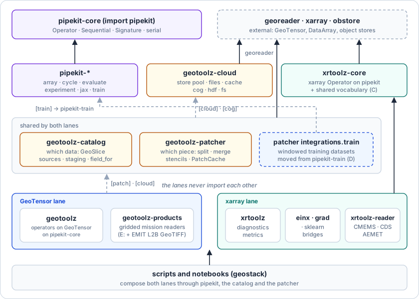
Figure 1:The geo data stack after the realignment. Solid arrows are base dependencies, dashed ones optional extras; the dashed blue box is the one new surface.
pipekit-core (
import pipekit) ownsOperator,Sequential,Graph,Signature, serialisation, control flow, the parallel maps, observation, QC and the shared protocols. It has no dependencies, and it never imports xarray, georeader or a geo package.pipekit-array, -cycle, -evaluate, -experiment, -jax and -train own the orchestration on top of that contract: Array API operators, cycles, benchmarks, tracking, the one Equinox model operator, and training loops. None of them imports a geo package (today pipekit-train does; see Section ??).
geotoolz-cloud (
import geocloud) owns object storage: the process-wide obstore pool, URI verbs, credentials, local copies, COG and HDF reads and writes, and the fsspec view. It imports georeader, obstore and rasterio, and never pipekit or another geo package.geotoolz-catalog (
import geocatalog) owns which data:GeoSlice, catalogs and their backends, discovery sources with footprints (STAC, CMR, earthaccess, GEE), matchup, staging andfield_for. It serves both lanes, and it only reaches geocloud and geopatcher through its[cloud]and[patch]extras.geotoolz-patcher (
import geopatcher) owns which piece for every carrier: split and merge, temporal stencils, the patch cache, and the integrations which put patching into a pipekit graph or (after D) into a pipekit-train dataset. It only imports pipekit and geocloud inside those integrations and fields.geotoolz-products (
import geoproducts) owns the decoding of missions whose output is a georeferenced raster: GOES-R ABI, Himawari AHI, Carbon Mapper and the toy sensor. Its presets bind geotoolz operators to channel names, and they only import geotoolz inside the[operators]extra.geotoolz owns the operators on
GeoTensor: reads of one source, radiometry, indices, masks, matched filters, plume quantification, and the GeoTensor marshalling for models. It imports pipekit, it only imports geopatcher and geocloud through extras, and it never imports the xarray-lane packages.xrtoolz-core (
import xrcore) owns the xarrayOperatorand, after C, the shared xarray vocabulary: the CF variable registry, validation and subsetting. It imports pipekit, xarray and NumPy, and after C also pandas, which the moved subsetting code uses and which it declares directly (xarray already requires it, so the install does not grow).xrtoolz-einx, xrtoolz-grad and xrtoolz-sklearn own labelled einsum, finite differences and the one xarray scikit-learn bridge. They import xrtoolz-core at most.
xrtoolz-reader (
import xrreader) owns the request-subset archives (CMEMS, CDS, AEMET) and the mission readers whose output is a swath, 2-D latitude and longitude, profiles or stations. After C, it imports the vocabulary from xrtoolz-core.xrtoolz owns diagnostics, metrics, and ocean and atmosphere physics on xarray. It imports the xrtoolz family and pipekit, and after C it only imports xrtoolz-reader through a
[reader]extra.The lanes meet only in scripts. A script which needs both lanes passes arrays between them. Radiometry and spectral indices stay in geotoolz, and xrtoolz does not grow a second copy.
Table 1:The dependency tiers after the realignment.
| Tier | Packages | May import | Role |
|---|---|---|---|
| 1 Foundations | pipekit-core; georeader, xarray, obstore (external) | nothing in the stack | contracts, carriers, bytes |
| 2 Framework and storage | pipekit-array, -cycle, -evaluate, -experiment, -jax, -train; geotoolz-cloud; xrtoolz-core | tier 1 | orchestration; object storage; the xarray operator and vocabulary |
| 3 Shared geo | geotoolz-catalog, geotoolz-patcher | tiers 1–2 (pipekit and geocloud through extras) | which data, which piece |
| 4 Lanes | geotoolz, geotoolz-products · xrtoolz, -einx, -grad, -sklearn, -reader | tiers 1–3, never the other lane | compute and decode on one carrier |
| 5 Entry points | geostack scripts and notebooks | everything | compose both lanes |
The running example: one methane scene through both lanes
The problem. A 256 × 256 scene of 30 m pixels in UTM zone 13N, observed in SWIR bands from 2100 to 2450 nm on 15 July 2026, contains a methane plume. The goal is the emission rate in kg s⁻¹. The scene is synthetic, so every stage has an exact answer which we can check against. The physics of the methane chain is scoped in GeoModels: the retrieval in radtrax · 1, the emission rate in plumax · 1, and where each piece moves in the package boundaries page. This page only checks how the data stack carries it.
The data. Let be the radiance spectrum of pixel , the background mean, the background covariance (rank 6 plus a diagonal), the unit-absorption target (the radiance change per ppm·m of methane, i.e. the Jacobian of the spectrum with respect to the enhancement, which we build from two absorption bands near 2300 and 2360 nm) and the enhancement in ppm·m, which peaks at 1500 ppm·m. Each pixel follows the linear model (1):
where the latent is standard normal and is a square root of the covariance:
The best that a matched filter can do is set by the noise floor , which is 103.9 ppm·m here.
Stage 1 · Which data (geotoolz-catalog → geotoolz-patcher)
TL;DR. Index the scene file, ask for the day’s slice over the scene, and get back one field that the patcher can split.
Problem. A catalog row holds a footprint, a time interval and a path. A GeoSlice is a request, made of the bounds , a time interval , a resolution and a CRS. field_for returns the rows which intersect , mosaicked onto its grid, as one RasterField.
1 2 3 4 5 6 7 8 9 10 11# Shapes: N_Sy = 40 bands, H = W = 256 pixels from geocatalog import GeoSlice, build, patch cat = build.build_raster_catalog([path], filename_regex=r"scene_(?P<date>\d{8})", date_format="%Y%m%d") # 1 row today # ξ = (𝓑, 𝒯, r, crs): the scene's bounds, 15 July, 30 m, UTM 13N slice_ = GeoSlice(bounds=(x0, y0 - H * res, x0 + W * res, y0), interval=pd.Interval(day_start, day_end, closed="both"), resolution=(30.0, 30.0), crs="EPSG:32613") # today field = patch.field_for(cat, slice_) # rows ∩ ξ → RasterField (N_Sy, H, W) today # → RasterField, domain shape (40, 256, 256)
Catalog to field; nothing in this stage changes under the plan.
This is the seam that Report 6 documents: the catalog only imports geopatcher inside geocatalog.patch, through the [patch] extra, which is why rule 4 holds today.
Stage 2 · Which piece, and the enhancement (geotoolz-patcher → geotoolz)
TL;DR. Cut the scene into overlapping chips, run a matched filter fitted on each chip, and blend the chips back into one enhancement map.
Problem. Chips are pixels on a side at a stride of , so the scene of pixels on a side has, by (4),
anchors per axis, and so chips, which we index by . On chip , the filter fits a median and a Ledoit–Wolf shrinkage covariance Ledoit & Wolf, 2004, and then it estimates the enhancement (5) Thompson et al., 2015 (derived in radtrax · 1, stage 5):
Each chip carries a separable Hann weight , where are the row and column of pixel inside chip and is sampled at the pixel centres. The merged map is then the weight-normalised sum over the set of chips which cover pixel , (6):
1 2 3 4 5 6 7 8 9 10 11 12 13 14 15 16 17 18 19 20 21 22 23 24# Shapes: N_Sy = 40 bands, N_chip = 128 chip side, N_patch = 9 chips from geopatcher import SpatialPatcher, spatial from geotoolz import matched_filter as mf from geotoolz.patch_ops import ApplyToChips, GridSampler, MergePatches from pipekit_ops import Sequential patcher = SpatialPatcher( geometry=spatial.geometry.Rectangular(size=(128, 128)), sampler=spatial.sampler.RegularStride(step=(64, 64)), window=spatial.window.Hann(), # ω(i) = sin²(π (i + ½) / N_chip) aggregation=spatial.aggregation.OverlapAdd(), ) # today pipe = Sequential([ GridSampler(patcher=patcher), # (N_Sy, H, W) → 9 × (N_Sy, 128, 128) today # α̂_n^(p) = J_hᵀ Σ̂_y^(p)⁻¹ (y_n − μ̂_y^(p)) / (J_hᵀ Σ̂_y^(p)⁻¹ J_h) ApplyToChips(operator=mf.MatchedFilter(target=j_h, fit_on_call=True)), # 9 × (N_Sy, 128, 128) → 9 × (128, 128) today # α̂_n = ∑_p w_n^(p) α̂_n^(p) / ∑_p w_n^(p) MergePatches(aggregation=spatial.aggregation.OverlapAdd(), domain=field.domain), # 9 × (128, 128) → (H, W) today ]) alpha = pipe(field) # GeoTensor (H, W), ppm·m today # → background std 107.2 ppm·m against σ_α = 103.9 (+3.2 %); peak 1588 against 1500 # → same CRS and transform as the scene; correlation with the truth 0.73
Split, filter and merge as one pipekit graph.
The same pipeline with an identity operator in place of the filter returns the scene with a maximum absolute error of 0.0, so the split and the merge add nothing of their own. This stage is the payoff of rule 5, as the patcher is carrier-agnostic, the filter is pure GeoTensor, and pipekit’s Sequential joins them.
Stage 3 · Mass and mask (geotoolz)
TL;DR. Turn the enhancement into column mass and keep the pixels that stand clear of the noise.
Problem. Let kg mol⁻¹ be the molar mass of methane and m³ mol⁻¹ the molar volume of air at 298.15 K and 1 atm. Then the column mass of pixel , in kg m⁻², is
The plume mask is the set of pixels in connected regions of at least 50 pixels where , and is the robust noise estimate .
1 2 3 4 5 6 7 8 9# Shapes: H = W = 256 from geotoolz import plume # ΔΩ = 10⁻⁶ α̂ M_CH₄ / V_m kg_m2 = plume.ColumnToMass(gas="CH4", units_in="ppm_m")(alpha) # (H, W) → (H, W) today # σ̂_ΔΩ = 1.4826 · median |ΔΩ − median ΔΩ| sigma_kg = 1.4826 * np.median(np.abs(kg_m2 - np.median(kg_m2))) # scalar user mask = plume.PlumeMask(threshold=3 * sigma_kg, min_area_px=50)(kg_m2) # (H, W) bool today # → σ̂_ΔΩ = 111.2 ppm·m equivalent; 1246 plume pixels, 3 outside the true 3σ_α region
Column mass and a 3σ̂ mask.
ColumnToMass matches the closed form (7) to 1e-12. Stage 3 only uses geotoolz, so nothing in it moves.
Stage 4 · Wind (xrtoolz → xrtoolz-core)
TL;DR. Take the 10 m wind from a reanalysis cube at the overpass and turn it into an effective wind for the plume.
Problem. Let and be the 10 m wind components (scalars per grid point and time step) on an ERA5-shaped grid of 24 hourly steps and 5 × 5 points, with m s⁻¹ at hour and m s⁻¹. The wind speed is (8), and the effective wind of Varon et al. Varon et al., 2018 is (9):
1 2 3 4 5 6 7 8 9# Shapes: T = 24 hourly steps, 5 × 5 grid from xrtoolz.atm import WindSpeed # U₁₀ = √(u₁₀² + v₁₀²) ws = WindSpeed(u="u10", v="v10", name="ws10")(era5)["ws10"] # (T, 5, 5) → (T, 5, 5) today U10 = float(ws.interp(time=overpass, latitude=39.5, longitude=-105.5)) # → scalar today # U_eff = 0.33 U₁₀ + 0.45 U_eff = 0.33 * U10 + 0.45 # scalar user # → U₁₀ = 4.722 m s⁻¹, U_eff = 2.008 m s⁻¹
Wind speed on xarray, interpolated to the overpass.
WindSpeed writes CF attributes through apply_cf_attrs and the Variable registry, which it imports from xrtoolz-reader today. After C, the same names come from xrtoolz-core and nothing in this block changes. A real run would download the cube with xrreader.CDSSource, whereas here we build it in memory so that the page needs no credentials. This is calibrated for a plume length (with the plume’s area), and stage 5 passes it to an operator whose length is the chord (see the note there).
Stage 5 · Emission rate (geotoolz)
TL;DR. Sum the mass inside the mask and divide by the time the wind takes to carry it the plume’s length.
Problem. geotoolz’s IMEEstimate sums the mass over the mask (with m² per pixel) and returns , where is the mask’s longest axis (the chord), along with at its default fraction. The method and its limits are derived in plumax · 1.
1 2 3 4# Shapes: H = W = 256; U_eff scalar from stage 4 # IME = ∑_{n∈𝒫} ΔΩ_n A_px, Q = U_eff IME / ℓ est = plume.IMEEstimate(wind_speed=U_eff)(kg_m2, mask) # (H, W), (H, W) → dict today # → IME 534.9 kg, ℓ 1651.1 m, Q 0.651 kg s⁻¹, σ_Q 0.325 kg s⁻¹
The emission rate from the GeoTensor and xarray stages together.
The script passes one float from the xarray lane to the GeoTensor lane and nothing imports across, which is rule 12. Within the mask the true IME is 584.6 kg, so the estimate is 8.5 % low. Fitting and on chips that contain the plume absorbs part of the signal, and with the true and the same mask gives +1.7 % (the notebook runs both and asserts both). That is a retrieval choice and not a packaging one, so it is out of scope here.
Stage 6 · The seams, as they stand (pipekit, xrtoolz, geotoolz-patcher)
TL;DR. Exercise the four places where today’s packages disagree, each of which becomes a workstream.
Problem. A Signature is a symbolic record of named dimensions and a dtype, for dimensions with names , sizes and the dtype , which Sequential.summary threads through every step. For example, a mean over axis 0 maps .
1 2 3 4 5 6 7 8 9 10 11 12 13 14 15 16 17 18 19 20 21 22 23# Shapes: T = 24, 5 × 5 grid wind_mean = Sequential([WindSpeed(u="u10", v="v10", name="ws10"), MeanScalar(axis=0)]) # today # (a) two Signature classes → workstream A wind_mean.summary(xrcore.Signature({"time": 24, "latitude": 5, "longitude": 5})) # → ValueError: too many values to unpack (expected 2) today wind_mean.summary(pipekit_ops.Signature(dims=(("time", 24), ("latitude", 5), ("longitude", 5)))) # → last step: Signature((latitude=5, longitude=5) float64) today # (b) the window dataset's stencil import → workstream D import geopatcher.time # → ModuleNotFoundError: No module named 'geopatcher.time' today from pipekit_train import XarrayWindowDataset # → ImportError: "XarrayWindowDataset requires `geopatcher` … not published # on PyPI … `uv pip install -e ../geopatcher`" today # (c) a pure-numpy stencil import loads the raster stack → workstream D import geopatcher.temporal.stencils # sys.modules gains georeader, rasterio, shapely today # (d) base installs → workstreams C, F importlib.metadata.requires("xrtoolz") # includes xrtoolz-reader>=0.0.2 today importlib.metadata.requires("geotoolz") # includes pipekit>=0.0.2 (another project on PyPI)
The seams the workstreams fix, run against the pinned revisions.
The XarrayWindowDataset message is wrong as well as unlucky, because geopatcher is installed and the module it wants was renamed. Report 11 records the same break as its A5.
Current-state audit
Six overlaps need action, whereas seven look like duplication and are not (Table 2; Figure 2 shows what the page’s sketches call). The audit read references/geostack/pipekit at ef3c17f, references/geostack/geotoolz at 088475e and references/geostack/xrtoolz at 308c7f2 on 14 October 2026.
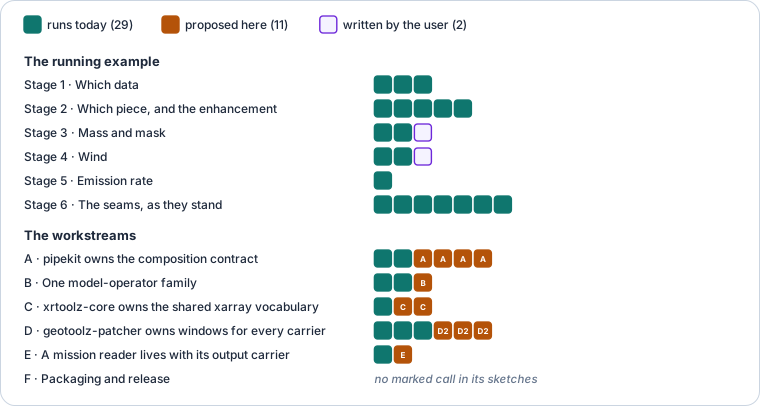
Figure 2:Of the page’s 42 marked stack calls, 29 run today, 11 are proposed by this report’s workstreams and 2 are code the reader writes (how to read it: conventions).
Table 2:Overlaps across the three repositories.
| Symbols | Defined in | Used by | Verdict |
|---|---|---|---|
Signature | pipekit/signature.py:29 (ordered pairs); xrcore/signature.py:64 (mapping) | pipekit-array reduce.py; 18 constructions in 5 modules of xrtoolz and xrtoolz-einx | Split ownership. Two layouts; mixing them in one Sequential fails (stage 6a) |
nested_config, callable_name, require_operator | pipekit/_base/operator.py:282, 293, 302 | geotoolz _src/config.py, augment/_src/operators.py; geopatcher integrations/pipekit.py | Split ownership. Private API used by two packages |
JaxModelOp ×2, EquinoxModelOp, ModelOp ×2, SklearnModelOp, SklearnOp ×2 | pipekit_jax/model_op.py:42; pipekit_train/adapters/equinox.py:66; xrtoolz/inference/modelop.py:30, 227, 257; xrsklearn/_src/operator.py:32; geotoolz/learn/_src/operators.py:45, 469 | EquinoxModelOp at 13 sites in pipekit-train; SklearnModelOp at 4 | True duplicate. Three backends, eight classes, one name for two unrelated classes |
Variable, REGISTRY, apply_cf_attrs, subset_bbox, subset_time, subset_where | xrreader/types/_src/ (2,341 lines; NumPy, pandas, xarray and the standard library) | 8 imports in 7 xrtoolz modules (atm, geo, viz) | Split ownership. Vocabulary in the downloader; xrtoolz requires xrtoolz-reader |
XarrayWindowDataset, _xreader.training_iterator | pipekit_train/xarray_window.py:134, _xreader.py:347 | pipekit-train users | Split ownership. Imports geopatcher.time (xarray_window.py:35, _xreader.py:380), removed by geotoolz #431 |
open_emit_ch4_l2b, open_ghgsat_ch4_l2, open_tropomi_ch4_l2 · goes, himawari, carbonmapper readers | xrreader/_src/local/openers/ (379 lines) · geoproducts/ | xrreader users · geoproducts users | Split ownership. Two homes for mission readers, no rule between them (Report 3, question 7) |
exact_quotient · count_steps | geopatcher/_src/temporal/stencils.py:55 · geocatalog.grid | temporal stencils · GeoSlice alignment | Healthy. Named for what they do since #434; the draft’s divide_evenly clash is gone |
obstore pool, files, cache, cog, hdf | geocloud | geocatalog staging, geopatcher CogField, geotoolz io.ReadHDF / ReadNetCDF, geoproducts HDF5 | Healthy. One pool per process, one home since #431 |
pipekit_ops.Cache · geopatcher.run.PatchCache · geocloud.cache · xrreader cache_path | four packages | Healthy. Operator results, patches across runs, local copies of remote objects, downloads: four jobs | |
geoproducts.goes.TrueColor · geotoolz.viz.TrueColor | goes/presets.py:152 · viz/_src/operators.py:124 | Healthy. The preset binds ABI channels to the geotoolz operator and imports it lazily | |
geotoolz.einx · xreinx | both lanes | Healthy. Each speaks its carrier: transform survival on GeoTensor, dimension names on xarray | |
geocatalog Source · xrreader DataSource | geocatalog.sources · xrreader/_src/base.py | Healthy. File inventories with footprints against server-side subsets | |
pipekit_ops.Retry · geocatalog.utils.retry_transient_io | Healthy. Retry any operator in a graph against retry one remote read |
Smaller findings:
The workspace roots pin pipekit two ways, and they collide. geotoolz’s
[tool.uv.sources]pins pipekit to commitef3c17f, whereas xrtoolz’s followsmainwith no revision. Installing both editable into one environment fails with “conflicting URLs for packagepipekit” unless the sources are switched off (uv pip install --no-sources), which is how we built this page’s environment.pipekit-train’s zarr floor is too low. Its
cache,s3,gcsandxreaderextras allowzarr>=2.18. However,dataset.py:478callszarr.storage.FsspecStore, which only exists in zarr 3.xrtoolz names an extra it does not have.
ocn/_src/kinematics.pysayspip install xrtoolz[oceanography], but the extras arewavelets,image,mapsandvector.Only geotoolz runs a packaging test. geotoolz, geotoolz-catalog and geotoolz-patcher have
tests/test_packaging.py, and CI installs all five geotoolz packages with no extras. xrtoolz and pipekit have neither, which is how the last two findings shipped, and geotoolz-cloud and geotoolz-products lack the test too.xrtoolz’s design docs predate pipekit and geopatcher.
docs/design/boundaries.mdstill assignsOperatorto an in-repocore, tiling toxrpatcherand ensemble DA toekalmX, andob-1.1-xrpatcher-integration.mdis still “proposed”. In addition,xrtoolz.rsandxrtoolz.iceexport nothing (Report 3).import geopatcher.temporal.stencilsloads georeader, rasterio and shapely. The package root importsfieldsandRasterField, and_src/fields/raster.py:23,fields/reproject.py:20and_src/matched/field.py:50import georeader and rasterio (which brings in shapely) at module scope, even though the stencils are pure NumPy.None of the 18 distributions is on PyPI, and every name is free except
pipekit(version 0.3.5 there belongs to another author).
Workstream A · pipekit owns the composition contract
Decision. There is one Signature, which is pipekit’s, and the helpers that other packages import from pipekit are public (Table 3).
Table 3:Workstream A’s moves.
| Symbol | Destination | Reason |
|---|---|---|
Signature (ordered (name, size) pairs) | stays in pipekit_ops.signature | positional operators (pipekit-array) need axis order |
Signature(dims) accepting a mapping as well as pairs, Signature.from_sizes(mapping, dtype), .sizes (read-only mapping) | pipekit_ops.signature, new | xrtoolz builds and compares signatures by name; a dict’s order is the axis order, so xrcore.Signature({"time": 24, …}) keeps its call semantics, not only its import |
dtype canonicalisation without NumPy: a table of the accepted spellings, each mapped to the name np.dtype(x).name gives ("f8", "<f8", "float64", float → "float64"; "f4", "<f4" → "float32"; the integer, unsigned, bool and complex codes likewise, with any byte-order prefix); a dtype object gives its .name and a scalar type its __name__, both then looked up in the same table; anything else raises TypeError naming the input | pipekit_ops.signature | xrcore’s one behaviour pipekit lacks; pipekit-core stays dependency-free, and gate A1 checks the table against np.dtype(x).name for every entry, so equal dtypes give equal signatures |
xrcore.Signature | re-export of pipekit_ops.Signature | from xrcore import Signature keeps working |
nested_config, callable_name | pipekit_ops.config | used by geotoolz and geopatcher |
require_operator | pipekit | used by geotoolz augment |
Widen pipekit’s class. We let the constructor take a mapping as well as ordered pairs (a mapping is converted to pairs in insertion order), and we add
from_sizes,sizesand dtype canonicalisation, whiledimsstays as ordered pairs. Existingxrcore.Signature({...})calls keep working unchanged.Re-export it from xrcore. We replace
xrcore/signature.pywith the re-export, construct withSignature.from_sizes(ds.sizes), and compare witha.sizes == b.sizeswherever order should not matter.Publish the helpers. We add the three names to pipekit’s public surface and replace the three private import statements.
1 2 3 4 5 6 7 8 9 10 11# Shapes: T = 24, 5 × 5 grid # Today: sig = xrcore.Signature({"time": 24, "latitude": 5, "longitude": 5}) # today wind_mean.summary(sig) # → ValueError today # After: # {d: N} in insertion order ↦ ((d₁, N₁), …, (d_R, N_R)) sig = xrcore.Signature({"time": 24, "latitude": 5, "longitude": 5}) # the same call proposed (A) xrcore.Signature is pipekit_ops.Signature # → True proposed (A) sig == pipekit_ops.Signature.from_sizes(sig.sizes) # → True proposed (A) wind_mean.summary(sig) # last: (latitude=5, longitude=5) proposed (A)
Stage 6a, before and after workstream A.
This revisits nothing in Report 2. Its Signature stays, and it only gains the mapping view that Report 3 found missing.
Workstream B · One model-operator family
Decision. Each lane owns how its carrier becomes an array and back, and each backend is wrapped once (Table 4).
Table 4:Workstream B’s moves.
| Symbol | Destination | Reason |
|---|---|---|
pipekit_jax.JaxModelOp | stays: the one Equinox wrapper | weight round-trip through the model registry |
pipekit_train.adapters.equinox.EquinoxModelOp | deprecated alias of the above; the adapter returns JaxModelOp | Report 11’s B1; it exists only so pipekit-train avoids pipekit-jax |
| pipekit-cycle in pipekit-jax’s base | pipekit-jax[diffrax] | only diffrax_model.py needs it, for RecursiveCheckpointAdjoint; this removes the reason for the twin |
xrtoolz.inference.ModelOp | stays: xarray marshalling for any callable | method=None means “call the model” |
xrtoolz.inference.JaxModelOp(model, *, jit=True, **kw) | deprecated wrapper: warns, wraps model in jax.jit, imported lazily, when jit is true (today’s default and today’s implementation), and builds ModelOp(model, method=None, **kw) | answers Report 3’s question 4; existing calls with jit= keep working for the deprecation period, and the wrapper adds no dependency: xrtoolz declares neither JAX nor Equinox, and Equinox stays out |
xrtoolz.inference.SklearnModelOp | deprecated alias of xrsklearn.SklearnOp | one xarray scikit-learn bridge |
geotoolz.learn.ModelOp, SklearnOp | stay | GeoTensor marshalling |
Return
JaxModelOpfrom the Equinox adapter, as Report 11’s B1 says, and aliasEquinoxModelOpto it.Move pipekit-cycle into pipekit-jax’s
[diffrax]extra, so that pipekit-train’s[equinox]extra can depend on pipekit-jax.Alias the two xrtoolz wrappers and teach
ModelOpto acceptmethod=None.
1 2 3 4 5 6 7 8 9# Shapes: X (T, 5, 5, N_f = 4) features; g_net(·; θ) : ℝ^N_f → ℝ^N_out, N_out = 1 # Today: op = xrtoolz.inference.JaxModelOp(net, feature_dim="feature") # today # After: model = pipekit_jax.JaxModelOp(net) # serialize_weights() today # stack non-feature dims: (T, 5, 5, N_f) → (N = 25 T, N_f); ŷ_n = g_net(x_n; θ): (N, N_out) op = xrtoolz.inference.ModelOp(model, method=None, feature_dim="feature", output_dim="output") # proposed (B) # → (T, 5, 5, output = 1)
A per-pixel Equinox emulator on the stage 4 cube, before and after.
Workstream C · xrtoolz-core owns the shared xarray vocabulary
Decision. The names that every xarray operator speaks live in xrtoolz-core, and xrtoolz-reader keeps its archives and readers (Table 5).
This corrects one point of the 7 October draft. xrtoolz does not import BBox or TimeRange from xrreader; it imports Variable, REGISTRY, apply_cf_attrs and the three subset functions.
Table 5:Workstream C’s moves.
| Symbol | Destination | Reason |
|---|---|---|
BBox, TimeRange, DepthRange, PressureLevels | xrcore.types | request vocabulary, shared with every reader |
Variable, REGISTRY, resolve, register | xrcore.types | CF variables used by xrtoolz.atm, geo and viz |
apply_cf_attrs | xrcore.types | used by xrtoolz.atm |
validate_dataset, validate_variable, ValidationReport | xrcore.types | the validators belong beside the registry they check against |
subset_bbox, subset_time, subset_where | xrcore.types | used by xrtoolz.geo |
Request, Station, StationCollection | stay in xrreader.types | reader-only |
xrtoolz-reader in xrtoolz’s base dependencies | a [reader] extra | the base install stops pulling the archive code |
xrtoolz.rs, xrtoolz.ice | removed | empty; radiometry and indices are geotoolz’s (rule 12) |
Move the modules from
xrreader/types/_src/intoxrcore/types/. They need NumPy, pandas, xarray and the standard library. Today pandas is only in xrtoolz-core’s tree through xarray, so the move addspandasto xrtoolz-core’sdependencies, because a package declares what it imports (rule 8).Re-export from
xrreader.typesfor the 0.x series.Repoint xrtoolz’s eight imports, move xrtoolz-reader to
[reader], and delete the emptyrsandicepackages.
1 2 3 4 5# Today: from xrreader.types import Variable, apply_cf_attrs, subset_bbox # today # After: from xrcore.types import Variable, apply_cf_attrs, subset_bbox # proposed (C) from xrreader.types import Variable # still works, same object proposed (C)
Stage 4’s imports, before and after workstream C.
Workstream D · geotoolz-patcher owns windows for every carrier
Decision. Windowed sampling for training lives with the stencils that define it, in geotoolz-patcher, and nothing in pipekit imports a geo package (Table 6).
Table 6:Workstream D’s moves.
| Symbol | Destination | Reason |
|---|---|---|
from geopatcher.time import … | from geopatcher.temporal.stencils import … | D1: the module was renamed in #431 |
XarrayWindowDataset, _xreader | geopatcher.integrations.train, behind geotoolz-patcher[train] (pipekit-train, xarray, zarr, Grain) | D2: removes the only pipekit → geo edge |
from pipekit_train import XarrayWindowDataset | removed, with no shim; the notebooks of Reports 11 and 15, which import it through a geopatcher.time alias, already try geopatcher.integrations.train first | it raises ImportError without that alias (stage 6), and a re-export would bring back the pipekit → geo edge D2 removes |
the raster fields, reprojection, matched fields and the RasterDomain alias | imported on first use from the package root | D3: a stencil import should load NumPy only |
xrpatcher in xrtoolz’s design docs | geopatcher’s XarrayField, GridSampler, MergePatches | D4: one patcher for both lanes |
D1 · Fix the import
This is Report 11’s A5: we import from geopatcher.temporal.stencils and make the error name the missing module. It ships first, because the dataset does not import at all today.
D2 · Move the dataset
XarrayWindowDataset subclasses pipekit-train’s TrainingDataset and rides its Grain path, so it needs pipekit-train, whereas the stencils need geopatcher. The package that knows both is the one which already has the integration modules: geopatcher has integrations/pipekit.py for operator graphs, and it gains integrations/train.py. Two callers in this repository use the old path, which are the notebooks of Reports 11 and 15. Both import from geopatcher.integrations.train when it exists and fall back to pipekit-train otherwise, so they keep running on either side of D2.
D3 · A cheap stencil import
The package root imports the raster field, the reprojection and the matched fields, which import georeader, rasterio and shapely at module scope. We load them on first use from the root (as geocatalog already does for its extras), so that geopatcher.temporal.stencils loads NumPy and nothing heavier. This is the lazy half of Report 7’s question 3. Moving them behind a [raster] extra is the other half, and it stays open.
D4 · The xarray lane uses geopatcher
We mark ob-1.1-xrpatcher-integration.md as superseded, rewrite the ownership map of boundaries.md from this page’s rules, and change the interpolate/_src/downscale.py docstring to compose with GridSampler and MergePatches.
1 2 3 4 5 6 7 8 9 10 11 12 13 14 15# Shapes: T = 24 hourly steps; input window 6 h, target window 1 h # Today: from pipekit_train import XarrayWindowDataset # → ImportError today # After: from geopatcher.temporal.stencils import TimeStencil # today from geopatcher.integrations.train import XarrayWindowDataset # proposed (D2) # x = (u, v)[t₀−5h … t₀]: (2, 6, 5, 5); y = (u, v)[t₀+1h]: (2, 1, 5, 5) ds = XarrayWindowDataset( source={"input": era5, "target": era5}, stencils={"input": TimeStencil(start="-5h", stop="0h", step="1h", closed="both"), "target": TimeStencil(start="1h", stop="1h", step="0h", closed="both")}, store_version="stage4-wind", split_guard=0, ) # proposed (D2) x, y = ds[0] # (2, 6, 5, 5), (2, 1, 5, 5) proposed (D2) # valid origins: |𝒪| = T − a₋ − a₊ = 24 − 5 − 1 = 18 today (stencils)
Training windows from the stage 4 cube, before and after workstream D.
The number of valid origins, the size of the set in (10), follows from the stencils. With steps of history and step of lead, an origin is only valid when both windows fit inside the steps, which today’s valid_origin_points confirms on the stage 4 cube:
Workstream E · A mission reader lives with its output carrier
Decision. A reader whose output is a georeferenced raster (an affine transform and a CRS) belongs to geotoolz-products, whereas one whose output is a swath, 2-D latitude and longitude, profiles or stations belongs to xrtoolz-reader.
This answers Report 3’s question 7, as the TROPOMI reader stays on the xarray side (Table 7).
Table 7:Workstream E’s placements.
| Reader | Output | Lives in |
|---|---|---|
| GOES-R ABI, Himawari AHI, Carbon Mapper, toy sensor | gridded GeoTensor | geotoolz-products (today) |
| TROPOMI CH₄ L2 | (scanline, ground_pixel) swath | xrtoolz-reader (today) |
| GHGSat CH₄ L2 | (y, x) with 2-D latitude and longitude | xrtoolz-reader (today) |
| EMIT L2B CH₄ enhancement, NetCDF container | (time, y, x) with 2-D latitude and longitude | xrtoolz-reader (today) |
| EMIT L2B CH₄ enhancement, distributed GeoTIFF | gridded GeoTensor | geotoolz-products, new: xrreader’s opener declines this format |
Write the rule into both packages’ contributing guides and into
AGENTS.md.Add the EMIT L2B GeoTIFF reader to geotoolz-products, which is the one format the rule assigns there that neither package reads today.
Index both packages’ subpackages in the capability index, so that a mission name which is read in two places is visible (Report 3).
1 2 3# Shapes: H × W ortho grid enh = geoproducts.emit.Reader(tif_path).read() # GeoTensor (H, W) proposed (E) ds = xrreader.open_emit_ch4_l2b(nc_path) # Dataset (time, y, x) today
One EMIT plume through each reader, after workstream E.
Workstream F · Packaging and release
Decision. The stack publishes under names it owns, it pins itself by version range, and every repository tests its own packaging.
F1 · Names
pipekit publishes as pipekit-core and keeps import pipekit. This revisits Report 2’s settled question 1: the import name stays pipekit, but the distribution name cannot, because pipekit on PyPI belongs to another project. The same decision serves the GeoML stack, which also depends on pipekit. As for Report 6 and Report 7, the public names are geotoolz-catalog and geotoolz-patcher, as the monorepo already builds them.
Recommended: pipekit-core. Alternative: a new import name as well, which renames every import in three repositories for no functional gain.
F2 · Pins and floors
Replace git pins with version ranges once a tier is on PyPI, and drop the
pipekitentries of both workspace roots from[tool.uv.sources].Raise pipekit-train’s zarr floor to
zarr>=3.0in itscache,s3,gcsandxreaderextras.Fix the xrtoolz hint, either by adding
oceanography = ["gsw"]or by changing it topip install gsw.
F3 · Packaging tests
We copy geotoolz’s tests/test_packaging.py (which fails when a module-level import is missing from [project.dependencies]) and its base-install CI job into every xrtoolz and pipekit package, and the test into geotoolz-cloud and geotoolz-products. However, that test only catches undeclared module-level imports, so two more checks cover the faults which F2 fixes:
A minimum-versions job installs each extra at its floors (
uv pip install --resolution lowest-direct) and runs a test which calls the code path the extra exists for. For pipekit-train’scacheextra, that isCachedDatasetwith an fsspec URL as its cache directory (memory://…, so no cloud is needed), which opens the store throughzarr.storage.FsspecStore(dataset.py:478) and fails on today’szarr>=2.18floor. A local path never reaches that line.An install-hint test collects every
pip install <dist>[<extra>]string in a package’s source and checks that<extra>is declared in its[project.optional-dependencies], which fails on today’sxrtoolz[oceanography]hint.
F4 · Release in tier order
Table 8 orders the releases by base dependency.
Table 8:Release order, by base dependencies. An extra may name a later tier; it resolves once that tier is published, and gate F4 checks the whole set.
| Release | Distributions | Base dependencies in the stack |
|---|---|---|
| 1 | pipekit-core, geotoolz-cloud, geotoolz-catalog, geotoolz-patcher, geotoolz-products, xrtoolz-grad | none |
| 2 | pipekit-array, -cycle, -evaluate, -experiment, -jax, -train, xrtoolz-core, geotoolz | pipekit-core (pipekit-jax after B) |
| 3 | xrtoolz-einx, xrtoolz-sklearn, xrtoolz-reader | xrtoolz-core (xrtoolz-reader after C) |
| 4 | xrtoolz | the xrtoolz family |
F5 · One stack check
A scheduled job installs all 18 distributions from PyPI into one fresh environment, with geotoolz-patcher[train] (which brings in pipekit-train’s Grain and zarr extras), and it runs each package’s fast tests and this page’s notebook with REPORT16_STATE=target. In that mode, the notebook checks the seams of stage 6 against the realigned stack: one Signature, the window dataset importing from geopatcher and building 18 windows of the right shapes from stage 4’s cube, a NumPy-only stencil import, no reader in xrtoolz’s base install, and none of the 18 distributions still requiring pipekit by name (after F1 that is another project, which pip would install beside pipekit-core without a conflict). By default, it checks them as they stand today, so that the page’s stage 6 stays reproducible at the pinned revisions.
Testing gates
Each workstream only merges when its gates pass (Table 9). The K gates are checks which the code passes today and must keep passing.
Table 9:Gates for the proposals and for what ships.
| Gate | Workstream | Passes when |
|---|---|---|
| A1 One Signature | A | xrcore.Signature is pipekit_ops.Signature, and stage 6a’s summary with a signature built by today’s call, xrcore.Signature({"time": 24, "latitude": 5, "longitude": 5}), ends in (latitude=5, longitude=5) (today ValueError); and for every spelling in the dtype table ("f8", "<f4", float, "i4", "?", …), Signature.from_sizes(sizes, dtype=x).dtype == np.dtype(x).name, with NumPy used only by the test |
| A2 Signature round-trip | A | every existing pipekit, pipekit-array and xrtoolz signature test passes against the merged class, with 0 failures |
| A3 No private imports | A | grep -r "pipekit\._" over geotoolz returns 0 lines (today 3) |
| B1 One Equinox wrapper | B | pipekit-train’s tests pass with the adapter returning JaxModelOp, and pip install pipekit-jax without extras installs no pipekit-cycle |
| B2 Alias parity | B | each deprecated alias returns outputs equal to its replacement to 0 on xrtoolz’s inference tests and emits exactly one DeprecationWarning; JaxModelOp(net, feature_dim="feature", jit=True) and jit=False both construct and agree to 0, in an environment with JAX and without Equinox |
| C1 Reader-free xrtoolz | C | importlib.metadata.requires("xrtoolz") lists no xrtoolz-reader outside [reader] (today it does), and import xrtoolz succeeds without it |
| C2 Vocabulary shims | C | for every name the move table sends to xrcore.types (BBox, TimeRange, DepthRange, PressureLevels, Variable, REGISTRY, resolve, register, apply_cf_attrs, validate_dataset, validate_variable, ValidationReport, subset_bbox, subset_time, subset_where), getattr(xrreader.types, n) is getattr(xrcore.types, n), so old imports and isinstance checks keep working |
| D1 Window import | D | XarrayWindowDataset imports with the pinned geopatcher and no shim (today ImportError); Report 11’s stage 8 pairs satisfy to 1e-5 |
| D2 No upward edges | D | grepping every pipekit package for geopatcher, geocatalog, geotoolz or xrcore returns 0 lines (today 2 files); the dataset’s content_hash on stage 4’s cube is identical before and after the move |
| D3 Cheap stencil import | D | in a fresh interpreter, import geopatcher.temporal.stencils puts none of georeader, rasterio, shapely, pyproj, geopandas, xarray, pandas, scipy, dask or zarr in sys.modules (today the first three) |
| E1 Carrier rule | E | the capability index lists no mission name under both geoproducts and xrreader except EMIT L2B, whose GeoTIFF and NetCDF containers are different carriers by design (stage table above); and those two EMIT readers agree on a fixture’s enhancement to 1e-6 |
| F1 Names | F | pipekit-core, geotoolz-cloud, geotoolz-products, geotoolz-catalog and geotoolz-patcher resolve to this stack on PyPI |
| F2 One environment | F | geotoolz and xrtoolz install editable into one environment without --no-sources (today a URL conflict) |
| F3 Packaging tests | F | xrtoolz and pipekit run test_packaging.py and a base-install job; the minimum-versions job fails on today’s zarr>=2.18 floor at FsspecStore and the install-hint test fails on today’s [oceanography] hint, and both pass after F2 |
| F4 Clean install | F | all 18 distributions install from PyPI into one fresh environment with no git URLs and no resolver conflict |
| F5 Stack check | F | the scheduled job passes on the latest release of every distribution, with the notebook’s REPORT16_STATE=target seam checks |
| K1 Noise floor (existing) | — | stage 2: the background standard deviation of is within 5 % of . Passes today: 107.2 against 103.9, +3.2 % |
| K2 Split and merge (existing) | — | stage 2: the identity operator through GridSampler, ApplyToChips and MergePatches returns the scene to 1e-5. Passes today: 0.0 |
| K3 Column mass (existing) | — | stage 3: ColumnToMass equals (7) to 1e-12. Passes today |
| K4 Emission rate (existing) | — | stage 5: IMEEstimate’s rate equals to 1e-12. Passes today |
Sequencing and risks
The name and the contract go first, because every later change either ships under the new name or touches operators which carry signatures. B, C, D and E are independent of each other and run side by side, and publishing waits for all of them (Figure 3).
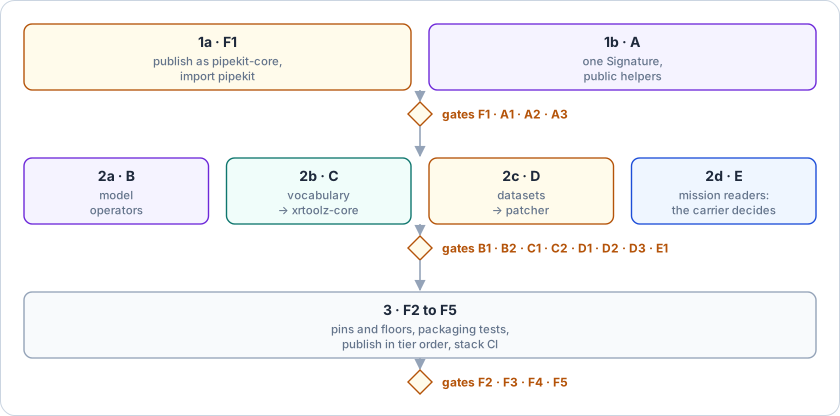
Figure 3:The name and the contract first, then four independent moves, then the release.
Ordered signatures break order-free comparisons. xrcore’s equality ignores the dimension order, whereas pipekit’s does not, so tests that build signatures from differently ordered dicts start failing. Fallback: we rewrite those comparisons to
a.sizes == b.sizesin the same PR, and gate A2 finds any that are left.Moved names break downstream code. Every move in B, C and D leaves a deprecated alias or re-export for the 0.x series, except
pipekit_train.XarrayWindowDataset, which cannot be imported today and whose re-export would undo D2. Fallback: if an alias cannot be kept (a class that changes base), we pin the old minor version in the dependent package until it migrates.The other
pipekitshares the import name. If its wheel also installs a top-levelpipekitmodule, the two cannot share an environment. Fallback: we say so in the README, and renaming the import is not proposed.Caches keyed on the dataset could go stale. A move which changed the content hash would orphan every cache built on it. However, it does not, because
content_hashhashes the literal string"XarrayWindowDataset"and the dataset’s own config (not its module), and gate D2 checks that the hash is unchanged. Serialised pipelines are not at risk either, because the dataset setsforbid_in_yamland never round-trips throughpipekit_ops.serial.Lazy imports hide a missing dependency. D3 makes the raster domain load on first use, so an install without georeader fails later than it does today. Fallback: geotoolz-patcher’s packaging test already installs with no extras, so we extend it to build each field once.
The carrier rule meets a hybrid product. A product shipped both as an orthorectified raster and as a swath (EMIT) gets a reader in each package. Fallback: that is simply the rule working, as the capability index shows both and gate E1 checks that they agree.
Open questions
Does geoproducts get an xarray output? A
to_xarrayon its readers would let the xarray lane use gridded missions without a second reader, at the cost of xarray in the base of geotoolz-products.Should geotoolz-cloud’s base drop georeader? It only needs georeader for the
GeoTensorthatcogandhdfreturn, so an index-only or bytes-only install would move those modules behind an extra, as Report 7 asks for the patcher.Does xrtoolz-reader use geotoolz-cloud for its downloads? Its cache and the cloud package’s
cachekeep local copies by different keys (a request against a URI). Sharing one would cross the lane rule at tier 2, which the tiers allow.
Upcoming work
Table 10 lists the follow-ups outside the workstreams.
Table 10:Follow-ups outside the workstreams.
| Follow-up | Where | Why |
|---|---|---|
| Point the 7 October draft at this page | the “Geo data stack” Claude doc | this page is the source of truth |
Rewrite boundaries.md from this page’s ownership rules | xrtoolz docs/design/ | it predates pipekit and geopatcher (D4) |
Fix the misleading XarrayWindowDataset error message in the same PR as D1 | pipekit-train xarray_window.py:40 | geopatcher is installed; the module was renamed |
| Index geoproducts, geocloud and the xrtoolz subpackages | geostack scripts/capabilities.py | E1 and the JaxModelOp clash need them (Report 3) |
References
Citations
The matched filter follows Thompson et al. Thompson et al., 2015, its covariance is the shrinkage estimator of Ledoit and Wolf Ledoit & Wolf, 2004, and the effective wind is the calibration of Varon et al. Varon et al., 2018.
Sources
pipekit, xrtoolz and geotoolz at the revisions pinned in
references/: theirpyproject.tomlfiles, public__init__modules, call sites, design docs and changelogs (geotoolz #420, #431 and #434 for the changes since the draft).The running example’s script and outputs, described in Section ??.
The 7 October draft of this plan, which this page replaces.
- Ledoit, O., & Wolf, M. (2004). A well-conditioned estimator for large-dimensional covariance matrices. Journal of Multivariate Analysis, 88(2), 365–411. 10.1016/S0047-259X(03)00096-4
- Thompson, D. R., Leifer, I., Bovensmann, H., Eastwood, M., Fladeland, M., Frankenberg, C., Gerilowski, K., Green, R. O., Kratwurst, S., Krings, T., Luna, B., & Thorpe, A. K. (2015). Real-time remote detection and measurement for airborne imaging spectroscopy: a case study with methane. Atmospheric Measurement Techniques, 8(10), 4383–4397. 10.5194/amt-8-4383-2015
- Varon, D. J., Jacob, D. J., McKeever, J., Jervis, D., Durak, B. O. A., Xia, Y., & Huang, Y. (2018). Quantifying methane point sources from fine-scale satellite observations of atmospheric methane plumes. Atmospheric Measurement Techniques, 11(10), 5673–5686. 10.5194/amt-11-5673-2018